
New Delhi. According to records available from the Indian Meteorological Department (IMD) since 2012, North India has experienced the heaviest rainfall in the last 14 days in the last 14 years. Between August 22 and September 4, the region recorded 205.3 mm of rain, almost three times more than normal, which is much more than the normal 73.1 mm. This intense rain wreaked seasonal havoc across the region, including cloudburst on Vaishno Devi route in Jammu and Kashmir, the worst floods in decades in Punjab, the third highest water level of Yamuna river in Delhi and massive landslides in Himachal Pradesh and Uttarakhand.
35% of monsoon quota completed in two weeks
According to the IMD, the 205.3 mm of rain that North India received in these 14 days is 35% of the normal quota of the entire four-month monsoon season. This intense rain has put North India on track to record the wettest monsoon in 37 years. So far in the monsoon season that began on June 1, the region has received 691.7 mm of rain, which is 37% more than normal. If normal rains also occur till the end of September, the total rainfall could cross 750 mm. In this case, this will be the wettest monsoon in North India after 1988 (813.5 mm) and will rank second in the last 50 years. 737 mm of rain was recorded in 1994.
What is the reason for this extraordinary rain?
IMD chief Mrityunjay Mohapatra said the period saw a rare combination of two weather systems. “The western disturbance, which brings moist winds from near the Mediterranean Sea, and monsoon winds from the east combined twice in a row. The first combination lasted from August 23 to 27, and the second will start from August 29 and continue till Friday,” he said. Such a combination leads to heavy rains and cloudbursts in the western Himalayan states, as seen in the Kedarnath floods in June 2013. Such combinations are unusual in the peak monsoon period of July-August, and it is extremely rare to happen twice in a row.
Understand the region-wise impact
In the last two weeks, almost all sub-regions of North India recorded excess rainfall, except eastern Uttar Pradesh. Punjab was the worst affected, which received 388% excess rain in the first week and 454% in the second week. In the week ending September 3, Haryana, Delhi and Chandigarh recorded 325% excess rain, Himachal Pradesh 314%, western Rajasthan 285%, Jammu and Kashmir 240% and Uttarakhand 190%.
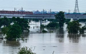
Natural disasters wreak havoc
This intense rain caused widespread devastation in north India. Pilgrims were inconvenienced after a cloudburst on the Vaishno Devi route in Jammu and Kashmir. Punjab witnessed the worst floods in decades, submerging many areas. The water level of the Yamuna river in Delhi reached the third highest level, increasing the risk of flooding in low-lying areas. Landslides in Himachal Pradesh and Uttarakhand caused heavy damage to roads and properties.
According to Mahapatra, this combination of western disturbances and monsoon winds may continue till Friday, with more rain expected in some areas. Weather experts have warned that such unusual weather events reflect the effects of climate change, and the frequency of such events may increase in the future. North India is now expecting normal rainfall for the rest of this monsoon season, but the current figures are enough to make it a historically memorable monsoon.
Share:


Indore (HO)
Bhopal
Jabalpur


©2026 Agnibaan , All Rights Reserved